
4 things to know about the weather:
- Weather alert: Severe storms
- Stormiest 3-10 p.m.
- September-ish Thursday, Friday
- Saturday showers possible
Be prepared for very active severe weather threats Tuesday afternoon. A severe thunderstorm watch is in effect for the D.C. area until 10 p.m.
Storm Team4 is in Weather Alert mode Tuesday and Tuesday night. The risk of severe storms peaks between 3-10 p.m. Our main threats will be damaging wind gusts in the 60-70 mph range and the risk of flash and urban flooding, but there will also be a tornado risk.
If your car is near trees, try to park away from them before the storms to avoid any falling tree branches.
Stay with Storm Team4 on air, online and on your device with the NBC Washington app, which is free on iOS and Android.
On a hot, humid summer day, many will be at the local pools and camps, so make sure all those places have a severe weather plan or know where you’ll go before severe weather threatens.
Typical of summer storms, rainfall amounts will vary widely, but the heaviest storms could produce rainfall rates over 2 inches per hour. That’s enough to overpower storm drains and small creeks and streams.
Make sure you and those you care about avoid high or fast-moving water at all costs. Turn around, don’t drown! Storms will linger late into the evening and gradually diminish after midnight.
Download the NBC Washington app on iOS and Android to check the weather radar on the go.
More storm and shower chances before September-like weather
Wednesday will bring two chances for rain.
Leftover showers will be possible into the morning commute, followed by dry time with breaks of sunshine. The amount of sunshine and heating will determine how much of a storm threat we face Wednesday afternoon.
Wednesday will be less active than Tuesday but still hot and humid enough for a severe weather threat. We’ll update you first thing Wednesday.
A strong cold front will come through the area Wednesday evening and deliver a most “un-summerlike” few days.
Both Thursday and Friday will be unusually cool and comfortable. Daytime highs in the low 80s, low humidity, and overnight lows dropping into the 50s for most areas away from the urban areas and the Bay. Very much a preview (or a reminder) of what Labor Day weekend weather is typically like.
Temperatures will stay below average for the upcoming weekend, with highs in the mid-80s, but the humidity will creep up a bit, and there will be a chance for a few showers on Saturday morning.
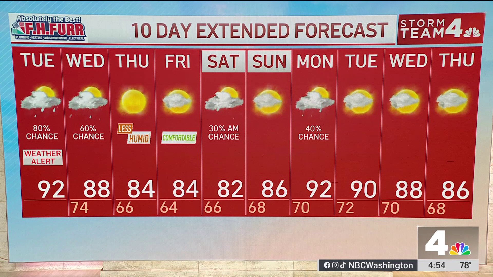
QuickCast
TUESDAY:
Mostly cloudy, very humid
Heat index around 100°
Heavy rain/thunder 3-10 pm
Damaging winds, flash flooding
Wind: southwest 10-20 mph
Chance of rain: 80%
HIGHS: 87° to 93°
TUESDAY NIGHT:
Stormy evening
Rain ending after midnight
Muggy and mild
Wind: southwest 8-18 mph
Chance of rain: 80%
LOWS: 68° to 74°
WEDNESDAY:
Mostly cloudy, humid
Few early showers
Scattered PM storms
Wind: southwest/west 5-15 mph
Chance of rain: 40%
HIGHS: 85° to 90°
THURSDAY:
Some AM cloudiness
Sunny afternoon
Much cooler, less humid
Wind: north/northeast 10 mph
Chance of rain: 0%
HIGHS: 78° to 84°
FRIDAY:
Cool, sunny morning
More clouds after noon
Really comfortable
Wind: northeast/east 10 mph
Chance of rain: 0%
HIGHS: 78° to 84°
Sunrise: 6:00 Sunset: 8:29
Average High: 90° Average Low: 73°
Stay with Storm Team4 for the latest forecast. Download the NBC Washington app on iOS and Android to get severe weather alerts on your phone.
from Local – NBC4 Washington https://ift.tt/gmtpXue




0 Comments